
The Beautiful Stewart Falls Hike at Sundance Utah
The canyons of Northern Utah are filled with some pretty great hiking adventures. As I pointed out in my last post, my daughter and I are trying to hike a different Utah canyon trail each week this summer. And a few days ago, we traveled up Provo Canyon to check out Stewart Falls – a popular hiking destination just above Sundance Resort. Stewart Falls is a spectacular two-tiered waterfall dropping 200 feet over a sheer mountain cliff on the east side of Mount Timpanogos – one of Utah’s highest peaks. The trail to the Falls is very scenic too. Let me show you what we discovered on the beautiful Stewart Falls Hike.
Some of the links in this post may be affiliate links. If you buy something after clicking one of these links, I may earn a small commission. This does not cost you anything extra and helps support this blog.
Contents
Which Stewart Falls Hike?
If you are trying to figure out how to best see this amazing waterfall, you will find that there’s actually more than one way to get to Stewart Falls. I generally scope out my trails on AllTrails.com. And on that site you’ll find two routes to the Falls – Stewart Cascade Trail and Stewart Falls Lower Trail.
The Stewart Cascade Trail trailhead is located above the Sundance resort, and begins at the Aspen Grove parking lot. It takes you to a mid-Falls viewpoint, and then you can access other parts of the Falls from there. This is the Stewart Falls hike featured in this post. It’s 3.6 miles round trip with a 656 foot gain. AllTrails rates it as moderate (and I would agree).
The Stewart Falls Lower Trail trailhead is located within the Sundance Resort and takes you to the base of the Falls. Parking at the resort during the summer is free. The hike from here is 3.2 miles round trip with a 816 foot gain. AllTrails also rates this trails as a moderate.
Plus, there is a third trail to the Falls which is reached by one of Sundance’s chairlifts. The chairlift eliminates some of the gain, but you’ll pay $30 for the privilege. According to the Sundance website, the hike is 3 miles round trip and rated as intermediate.
But regardless of how you get there, the visual reward is worth it…..

Getting to the Stewart Cascade Trailhead
The Stewart Cascade Trailhead is located at the Aspen Grove parking lot. The easiest way to reach it is via Provo Canyon, and then up the Alpine Loop Scenic Byway towards Sundance Resort.
Five miles up the Byway, and after you’ve passed both the entrance to Sundance Resort and BYU’s Aspen Grove Conference Center, you’ll come to a toll both. Here you’ll need to pay a $10 fee to continue on up the road. And, as you might be able to make out in the picture below, it’s currently cash only.
Here’s a link to the National Forest Service website for a look at the complete fee schedule.
(Note: The America The Beautiful National Parks Pass will also get you past the booth.)

The Aspen Grove parking lot is located just a few yards past the booth. It’s a sizable parking lot with great views of Mount Timpanogos. You’ll also find pit toilets here so that you can start your Stewart Falls hike a little more comfortably.

Near the toilets, you’ll find a large trail head marker for the Stewart Falls hike – remember, this particular route is called the Stewart Cascade Trail. (Notice that on the sign it’s called Stewarts Cascades Trail. And on the National Forest website it’s called Stewart Cascades Trail. So there seems to be a lot of confusion about how many “s”es there really are in its official name.)

Note that another popular trail also begins at this parking area – the trail to the top of Mount Timpanogos. Be sure you choose the right trail. The Mount Timpanogos hike is 14 miles round trip with a 5000 foot gain!
Here’s What You’ll See On The Hike
The hike starts out flat with views up to the surrounding mountain peaks. Very quickly though, you’ll start a moderate ascent.

During that ascent, you’ll have to negotiate three different fallen trees. But, they are pretty easy to climb over. Here’s a look at two of them…


Soon you’ll find the trail flattening somewhat as you start to enjoy great views down over Sundance and out across Provo Canyon…

You’ll pass through aspen groves and fern-covered forest floors…

Pass by a few meadows….

And ultimately reach the trail’s summit, with even better views out across the canyon…

From here, the trail mostly descends towards the Falls. Along this stretch it can be quite rocky in some places…

As you continue your descent, the waterfall will come into view. It ultimately gets closer and closer as you vacillate between watching your footing and admiring your first glimpses of the rushing water…

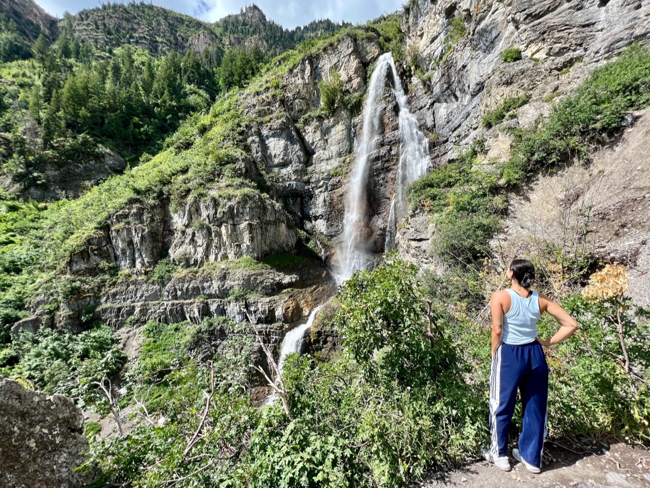
And then there it is…Stewart Falls…in all its splendor!

As I mentioned earlier in the post, this particular Stewart Falls hike takes you to a rocky cliff ledge overlooking the falls, where along with many other hikers, you’ll likely take your own version of this picture….

This is a popular hike, so expect to wait in a short line to get your photo. Once it’s your turn, expect to have plenty of hikers offer to take your photo. And, expect to return the favor.
Further Stewart Falls Exploration
Once at the first ledge, you’ll inevitably notice a hiker or two over on an opposite ledge, much closer to the rushing water. And there’s a trail that will take you over there. However, it’s tricky.
Full disclosure…I’m battling some foot tendonitis during this summer hiking season, and so am avoiding really steep hiking. And we are leaving for our next European adventure in a few weeks, so I am also very injury-averse right now.
But my daughter immediately set course for the other ledge….

You can see that although there is a defined trail over to the other ledge, it starts by just basically dropping straight down off the main viewpoint.
And then it ascends steeply on the other side.
But once you make that ascent, you’ll be really close to the rush of water. You’ll find my daughter right next to the Falls in this picture…

Ultimately, she continued on to the other side of that far ledge, disappearing from my view. I will admit this is when I got nervous. I had no idea what was over there, and continue to anxiously scan the lower tier of the falls for a blue-clad body shooting through.
It was with great relief that I saw her eventually come hiking back across. She said it was indeed slippery, but she was very careful. This is what she saw….

Down Below
The other exploration option from the main viewing ledge is to continue down to the base of the Falls. A defined trail takes you down to the flat, and I’m guessing that this pathway is still part of the official Stewart Cascade trail.
It’s quite a steep decline though. And again, because of my foot, we opted out. But, lots of other hikers made the descent, where they joined those that had hiked up from Sundance along the Stewart Falls Lower Trail.

A Few Additional Tips
It took us two hours to complete this Stewart Falls hike from start to finish, including the time we spent taking in the penultimate views. Along the way, we passed many families with small kids. While it certainly could be considered a family friendly hike, it’s still moderately difficult in spots. So plan on much longer than two hours with little kids.
I’d read that the hike could be buggy. Plus it had rained the night before our visit, so I especially planned on a buggy hike. In reality, I didn’t notice many. Though we did apply a picaridin-based insect repellant in the parking lot prior to heading up the trail.
As I mentioned, the trail can be quite rocky during its latter half. I would recommend hiking in good quality hiking shoes.
The trail is covered in shade for about half its length. Still, don’t forget the sunscreen and water.
A Couple Post Hike Suggestions
When you’re finished with this hike, and if you have time, then you should consider driving along the rest of the Alpine Loop Scenic Byway. After all, you will have already paid your $10 for the privilege. It’s 15 miles from this Aspen Grove to the other side, and takes about 30-40 minutes to complete.
The winding road will take you deeper into the Uinta-Wasatch-Cache National Forest, cresting at 8000 feet, then down through American Fork Canyon. Along the way you’ll have some pretty spectacular views of Mount Timpanogos (11,752 ft) And in the Fall, this is one of the very best scenic drives for seeing the amazing Fall colors in Utah.
At the other end, you’ll finish near the town of Alpine. And if you need a treat after your Stewart Falls hike, then do what we did and stop at Burgess Orchards for a fresh peach sundae.

More Utah Hiking
As I mentioned earlier in this post, my daughter and I have spent quite a bit of time hiking in northern Utah’s canyons the past two summers.
Similar to this Stewart Falls hike near Sundance Resort, many of these hikes are located at some of Utah’s most beloved ski resorts. And I’ve written about several:
The Snowbird Tram in Summer – Utah Mountain Hiking at 11000 ft
Two Popular Alta Utah Hikes – Albion Meadows & Cecret Lake
Hiking at Brighton Utah – Silver Lake, Twin Lakes, & Lake Solitude
And across the Alpine Loop from Stewart Falls – on the American Fork Canyon side – you’ll find another great waterfall hike to Scout Falls.
Plus, you don’t necessarily even need to go up into the canyons to find great hiking in northern Utah. Here’s a post all about a favorite hike in the foothills near my house in the Salt Lake Valley.
The Bear Canyon Suspension Bridge – My Favorite Local Hike
And then of course, Southern Utah is world famous for hikes like these:
Canyoneering a Slot Canyon in Southern Utah with East Zion Experiences
My side quest to get closer to the falls was definitely worth it
And you survived!!